El Al’s Latest Zmanim App. Note the latitude and longitude on the display as well as the version number.While there have been many technical updates to El Al’s in-flight zmanim app since it rolled out, none included changes to the visual user interface. In February, El Al rolled out a long awaited update by FlightPath3D to the user interface based on feedback received since the initial system was rolled out. The new UI has many enhancements including:
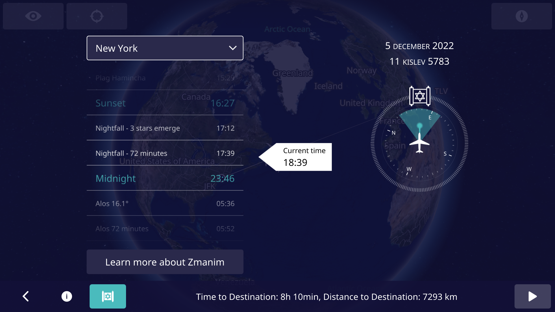
Displaying the latitude and longitude on the main screen to allow people to more easily validate the accuracy of zmanim calculations and simplify bug reporting. This feature involved a security review by El Al. To enhance reporting even further, the app version is displayed on the main screen. I am not aware of any software that shows the version on the main app screen, but we are doing what we can to help resolve any potential issues, and knowing the version number can help. Since feedback is often in the form of a picture of the screen, displaying the aircraft location and version number on the screen simplifies debugging issues.
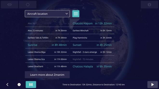
A UI toggle to show a more extensive list of zmanim (not just a few past and upcoming ones).
Avoid showing the zmanim screen before takeoff (projections on the ground are too inaccurate, since the system has no idea when it will take off). Even showing zmanim for specific cities prior to takeoff was shelved in a UX review since it would likely confuse users who would think that it reflected the flight zmanim. The icon for displaying zmanim shows up as soon as the flight is underway.
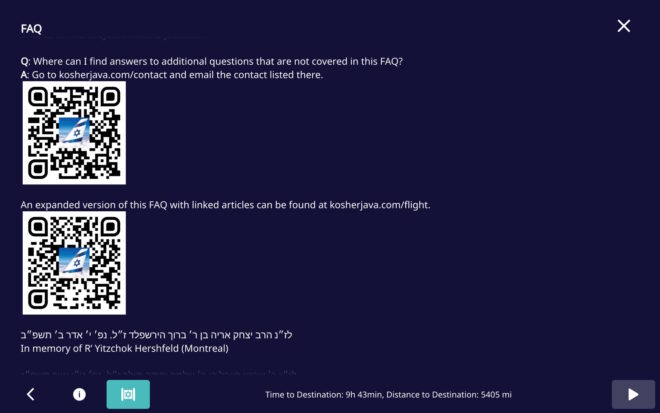
Minor FAQ changes, including the addition of QR codes to simplify contacting us to report issues. Thank you YCS for the suggestion.
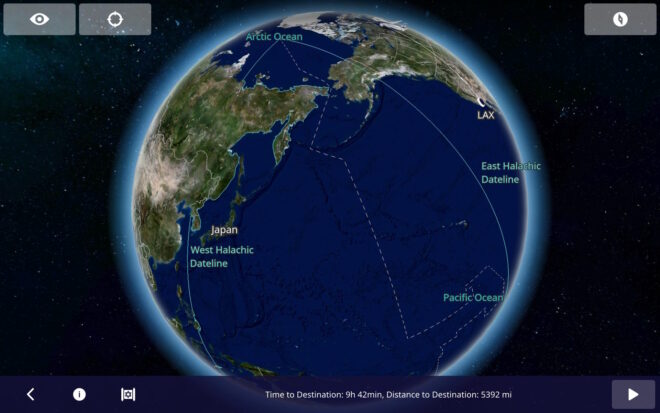
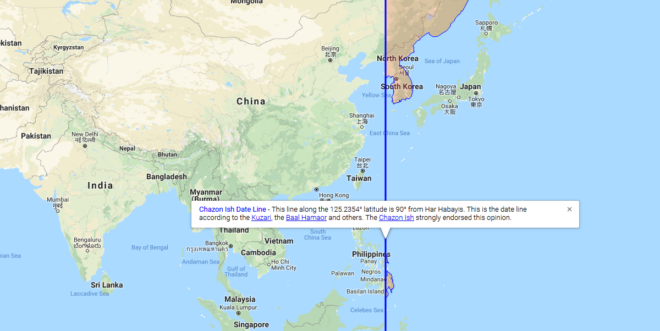
The Halachic Datelines (the Chazon Ish and Rav Yechiel Michel Tucazinsky) were added to the flight map. Note that graira / גרירה is used in the Chazon Ish (west) date line, but not Rav Tucazinsky’s (east) date line, since he was seemingly מסופק / unsure about concept. This change was a mapping update, and not a zmanim app update.
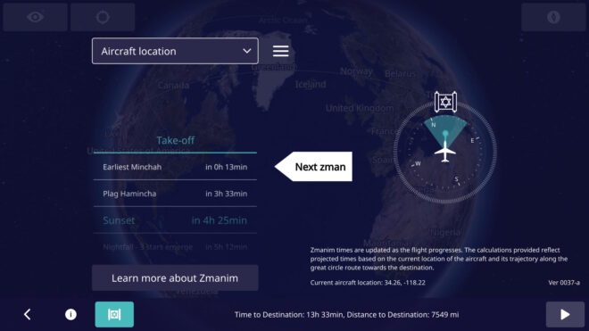
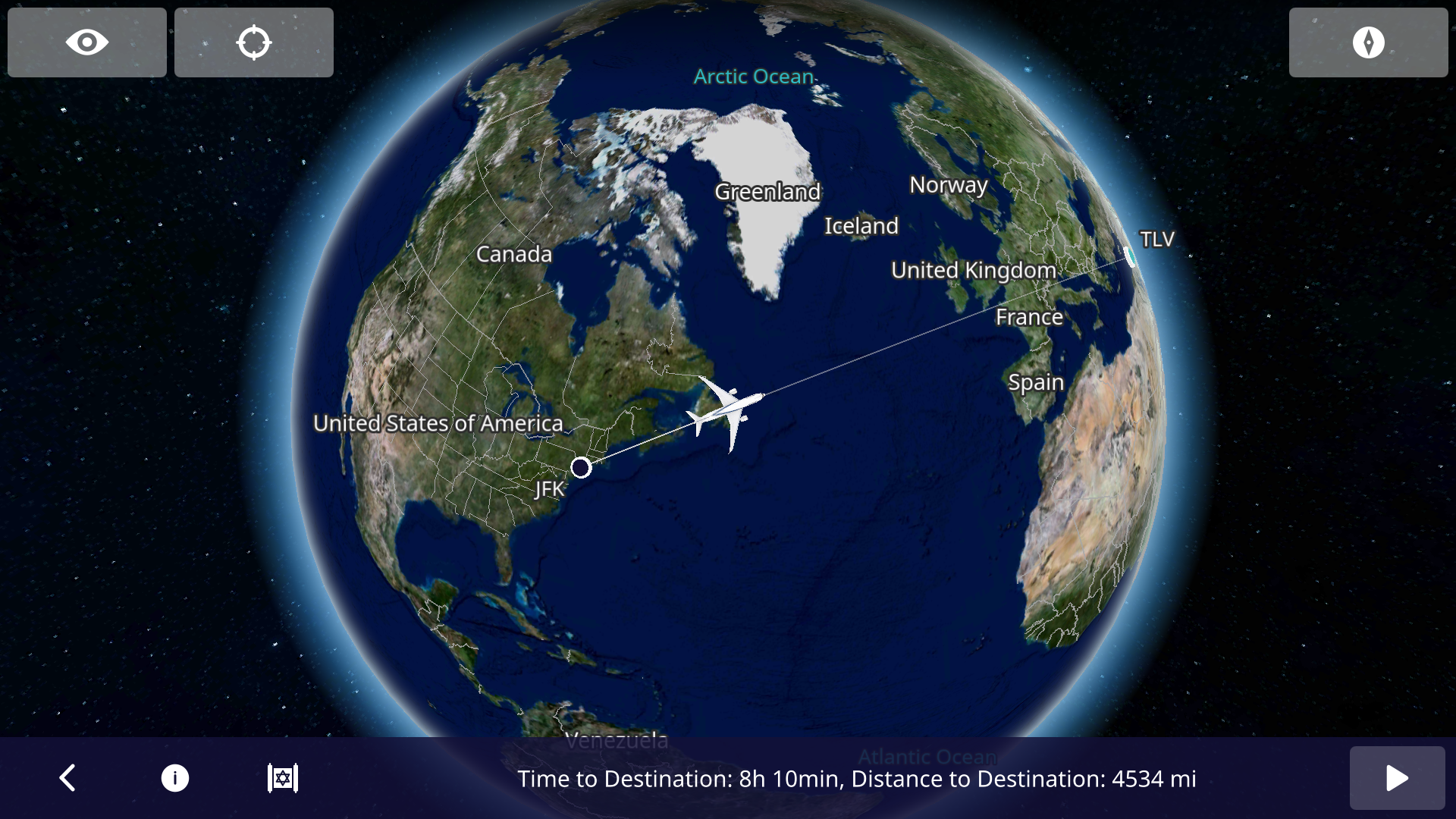
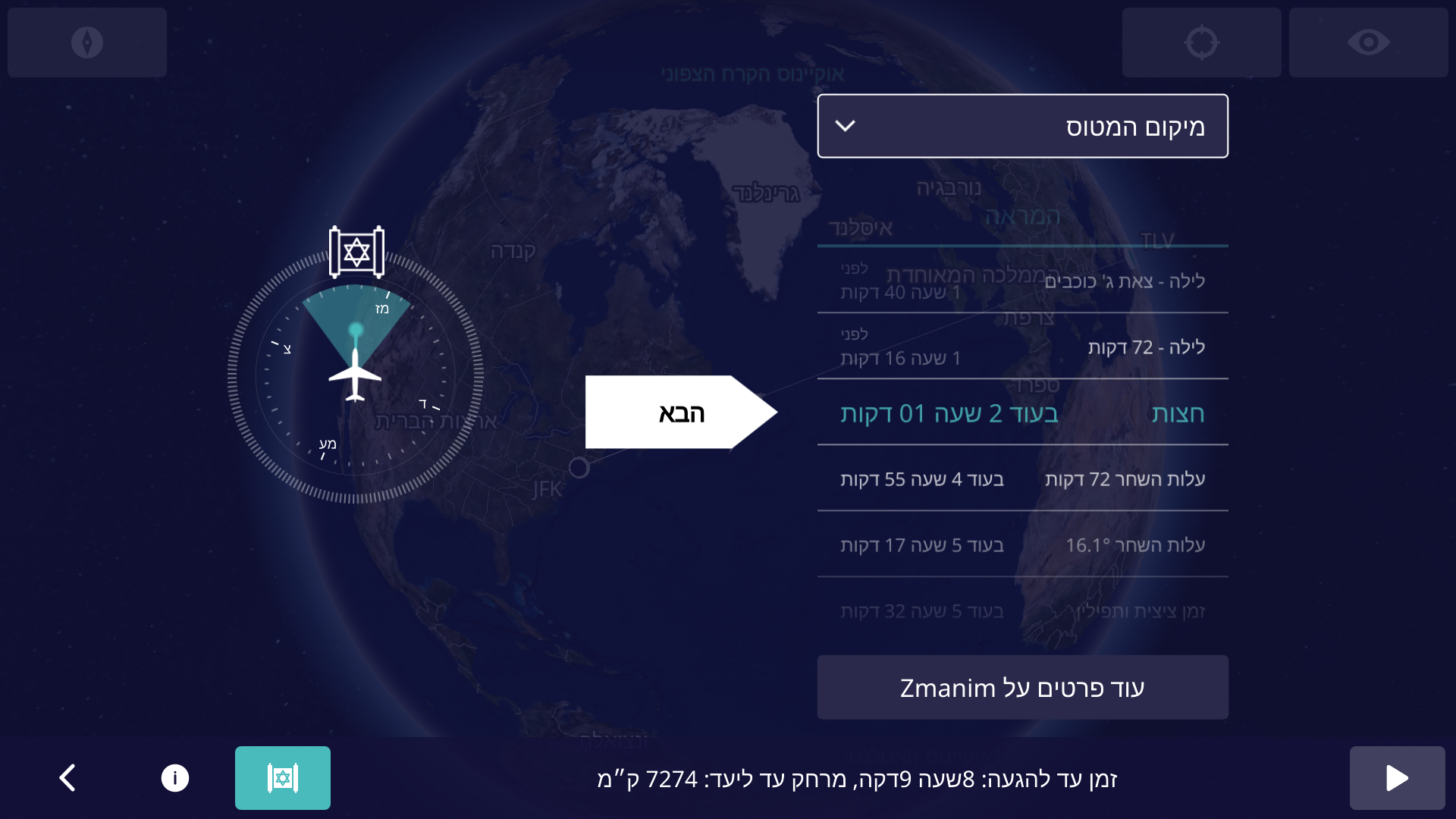
In an earlier Inflight Zmanim Calculations – Why So Complex? post, I outlined the complexity of calculating zmanim for flights. Back in Aug 2022, Dan’s Deals posted the exciting news that Zmanim were added to El Al’s flight entertainment system. This had not been formally announced by El Al at the time since the app was really in an (unannounced) alpha/beta testing phase. A careful examination of the screenshots by members of the #zmanim channel in the Frum Software Developers Slack, showed that it was powered by the KosherJava zmanim library. It should not have been surprising that it was found and used without my knowledge, since it is a free, well documented and easy to use open source library. After a number of issues with the zmanim app were reported to me (I want to thank all of those who took the time to track me down to report the issues), Rabbi Dovid Heber reached out to El Al, and Tal Kalderon, the head of El Al’s Inflight entertainment & Connectivity team reached out to me for assistance. This lead to meetings with Boris Veksler the CEO of FlightPath3D who integrated the KosherJava zmanim code into their flight maps as an optional module that El Al is using.The FlightPath3D in-flight mapping app on El Al with the zmanim app Magen Dovid icon on the bottom leftBoris made it a personal mission to perfect the product and a series of fixes were deployed until the final release of the Prayer Room / Mesivta Derakia app was deployed on El Al aircraft on 5 Feb, 2023. At this point, the app started displaying accurate zmanim. Boris and the FlightPath3D team put a lot of effort into perfecting it into an easy-to-use app. To ease understanding of zmanim on flights that cross time zones, the app shows countdown times to the upcoming zmanim.The El Al Zmanim app showing the default current aircraft location zmanim For example, El Al flight LY 26 from New York to Israel departing at 9pm will show a countdown to chatzos/midnight, alos hashachar (two variants) and later zmanim (such as misheyakir, sunrise, etc.), displaying a countdown, with the number of hours and minutes to upcoming zmanim. Zmanim are calculated based on the plane’s current location, speed and the flight path. Since headwinds and tailwinds (as well as in-flight route changes) can significantly change the time that zmanim will be reached, the times to the upcoming zmanim are recalculated multiple times a minute. This significantly reduces the challenge to passengers, since precalculated zmanim do not come close to real time calculations on the flight. The app also shows a compass with the bearing to Yerushalayim / Jerusalem (map). The FAQ that is part of the zmanim app on the aircraft appears in a hyperlinked version at El Al In-Flight Zmanim FAQ on this site. The app defaults to the Aircraft location but can be changed to show zmanim for multiple international citiesThe El Al zmanim app displaying zmanim for New York, displayed in the time and time zone of those cities. The app works in both English and Hebrew, based on the language selected in the flight entertainment system. A thank you goes to R’ Chaim Keller of the indispensable Chai Tables project for allowing the development team access his flight path algorithms. The FAQ would not have been possible without help of translators and copy-editors.The El Al Zmanim app in Hebrew A special thanks to Effie Freiner from Lakewood for the Hebrew translation (the “Yeshivish” Hebrew posed its own set of challenges), and to my wife and Dovid Nachfolger for clarifying the language and grammar in the English FAQ. I spent time with Rabbi Dovid Heber, Rabbi Dovid Braunfeld, Rabbi Yisroel Harfenes and Reb Solly Tropper reviewing the various complexities of calculating in-flight zmanim before the app left the βeta stage and went live.
Developing Software for Aircraft
Developing apps for use on an airliner has a series of challenges, in particular for in-flight entertainment (IFE) systems. It is a complex process that requires a deep understanding of the aviation industry and the systems onboard the aircraft.
First, the hardware hosting the apps goes through stringent safety certifications and has to pass a series of requirements. These include being isolated from any cabin and aircraft controls. The most they can do is access the flight management system (FMS) in read-only mode, with no ability to push data to the FMS. These certifications are done for each aircraft configuration and can take a year or more to complete.
Software and the associated apps also follow similar certification processes. The software must be designed to work seamlessly with any IFE systems already in place on the aircraft. Thus, it has to adapt to new and older hardware and operating systems and understand and adapt to idiosyncrasies in the data provided by the FMS. FlightPath3D is a leading provider of interactive mapping software for IFE systems. This type of software provides passengers with real-time information about their flight’s location, altitude, and speed, as well as other relevant data such as the estimated time of arrival and the distance to the destination. This made FlightPath3D a natural vendor for the zmanim work. FlightPath3D has a wealth of experience in developing high-quality software solutions that meet the needs of airlines and passengers and adapt to the particular hardware installed onboard.
לז״נ אבי מורי הרב יצחק אריה בן ר׳ ברוך הירשפלד ז״ל. נפ׳ י׳ אדר ב׳ תשפ״ב. In memory of my father R’ Yitzchok Hershfeld (Montreal).
לז״נ חמי ר׳ שרגא פייבל בן ר׳ שלמה יהודה מילר ז״ל. נפ׳ ט״ו אייר תשפ״ג. In memory of my father-in-law R’ Feivel Muller (Brooklyn / Lakewood).
Determining zmanim times while on an airline flight is rather complex compared to calculating it for a fixed location. Some of the complexity involves:
Where you are currently located
Your Speed
Direction of travel / flightpath
The above 3 variables impact the calculation of what the zmanim are in your current location and where you will likely be when various zmanim are met.
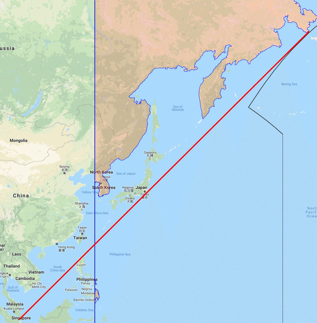
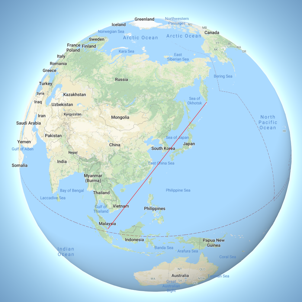
Surprisingly, the hardest part is figuring out your current location. The shortest point between 2 points on the globe is the great circle route. Though it is the shortest path, airliners rarely fly this way. To take advantage of prevailing winds such as the Gulf Stream, or to avoid bad weather, airlines often fly much longerroutes and as a passenger you often do not know exactly where you are. Yes, the airline shows you a nice location map, but getting your exact coordinates from the map is not something that they usually supply. From a practical perspective, many people on domestic and short international flights will manage to figure out davening times by themselves. As a general rule of thumb, it is time for Shacharis when the sun rises and time for Maariv when it gets dark. Please keep in mind that most poskim are of the opinion that we use zmanim at sea level elevation, or ground level, and not the 37,000 foot elevation of the flight. This elevation results in a difference of approximately 20 minutes in sunrise and sunset times. Not sure when Mincha time is? Wait until shortly before sunset. Just keep in mind that when flying due east (such as a flight from NY to Israel), you are flying in the opposite direction as the sun and the time for davening is compressed. While you may expect sof zman krias shema to be 1/4 of the way into the day, in this case the davening window is compressed into a much shorter time. The real complexity is in flights that cross the halachic dateline, polar flights and to a lesser degree, cross-Atlantic and Pacific flights. This article will not delve into the halacha of in-flight zmanim, but solely on the technical aspects of figuring out the zmanim times.
GPS
Using your phone’s GPS to identify your in-flight location, or even a standalone GPS device will usually not work once you are away from cell towers (where your GPS no longer has the assistance of A-GPS). GPS signals are very weak and your GPS receiver typically does not have an antenna strong enough to pick up the signals in an aluminum or even newer carbon fiber composite airplane like the Airbus A350 and Boeing 787. To receive a signal, an external GPS receiver is usually required and assuming that you can get a signal (it helps if the external receiver is placed by a window), we can proceed. Note that while you would expect that the CFRP body of a Boeing 787 would allow for a much stronger signal than aluminum airliners, the graphite (and probably other materials) in the 787 and A350, CFRP in conjunction with the electrochromic windows on the 787, completely block GPS signals. In addition, to protect from lightning strikes, the A350 has a metal mesh embedded in the CFRP that further reduces the signal penetrating into the aircraft body. It is this shielding as opposed to GPS jamming that blocks signals on El-Al (and other airlines) 787s and A350s. In my testing with an external GPS device designed for aviation such as the Dual XGPS 160, the composite A350 and 787 both do not allow enough GPS signal through for a GPS receiver to provide a location fix. It may be surprising that it is easier to receive the weak GPS signal in an aluminum fuselage than a composite one, but keep in mind that carbon fiber is an excellent electrical conductor. Carbon fiber was used as the filament in Thomas Edison’s early light bulbs and does not let RF signals through and effectively acts as a Faraday cage. If you are able to receive a GPS signal, you can accurately calculate zmanim for your current location using tools such as the KosherJava zmanim map. Just change the latitude and longitude to what you see in your GPS in the URL https://kosherjava.com/maps/zmanim3.html?lat=75.74&lng=-63.22&zoom=3. While not an ideal solution, it does work. The same works for the rare airlines whose maps do show accurate GPS coordinates. Please note that Wi-Fi based geolocation will not work on your flight (in my testing it gave the location of the service provider headquarters).
Precalculated Flight Paths
Another way to figure out where you are located when in the air is via a precalculated flight path. This allows programs such as the Chai Tables Chai Air Times program for Windows and Android to work. However, they just calculate a great circle route between the origination and destination locations, something that is not very accurate. Currently MyZmanim’s Inflight charts are the most practical. These charts calculate the average path of the 5 previous flights in an attempt to better estimate your flight path and provide precalculated charts based on the time you take off. Since it is just an estimate, the charts provide a relatively large window of time where zmanim may happen. This is painful and causes a lot of confusion and uncertainty, but is probably unavoidable. While this solution is currently the best that I am aware of, there are a number of issues with it. For one, much of the flight path over the oceans and Arctic that are provided by services such as FlightAware and others (that are used by MyZmanim) are just educated guesses for cross oceanic or Polar flights, since there are no ADS-B receivers in much of this area. As a matter of fact, this terrestrial ADS-B receiver-free area comprises 75% of the globe. Even if the previous flight paths were accurate, your current flight may be very different. Flights such as the Cathay Pacific flights from the NY area to Hong Kong fly either east or west depending on wind conditions. MyZmanim deals with this scenario by providing both east and west maps (based on the in-flight map you would use one or the other) and indicating the portion of a flight-path that is unknown, but this is a warning that does nothing to help you accurately calculate zmanim.
ADS-B Receivers
Every airliner broadcasts its position, heading, altitude and speed using ADS-B. A technical user can bring an ADS-B-receiver with him on the flight and use it to retrieve the current information on his flight. This would work even when there are no ground based ADS-B receivers. This is something costly and beyond the technical ability of the vast majority of flyers.
The future
Due to issues in tracking flights that came to light with the disappearance of Malaysia Airlines Flight 370, satellite based ADS-B tracking is rolling out and will be mandated. This will make it much easier for services such as MyZmanim to provide more accurate pre-flight estimates, since services such as Flight-Aware will be able to provide more exact historical flight paths. For users who do have in-flight Wi-Fi, services such as FlightAware will be able to provide almost real time location (note that many services have a 5 minute delay and are not really real-time), allowing future Wi-Fi connected zmanim apps to tap into this and provide accurate zmanim.
A primer for this halachic dateline post if you are not familiar with the subject, is the earlier Halachic Date Line Map post about the Jewish קו התאריך date-line. Based on the opinion of the בעל המאור Ba’al Hamaor, the חזון איש Chazon Ish ruled that the dateline is 90° east of Yerushalayim, and it can’t split a landmass. The concept of גרירה / graira is used to drag the land past the dateline to the water’s edge. This concept of graira is based on the יסוד עולם Yesod Olam, a תלמיד/disciple of the רא״ש Rosh. For this reason, according to the Chazon Ish, Korea and Australia follow the local date and not the previous date.
Islands Connected to Mainland by a Bridge
A question touched on in the previous article that was mostly theoretical, was about an island connected by a bridge to the mainland. Would the concept of graira apply to the island? The kollel members in Melbourne and others do not visit Phillip Island on Sundays for this reason, but Chabad chassidim who do not follow the Chazon Ish’s opinion, do visit Phillip Island on Sundays.
Islands in Bays
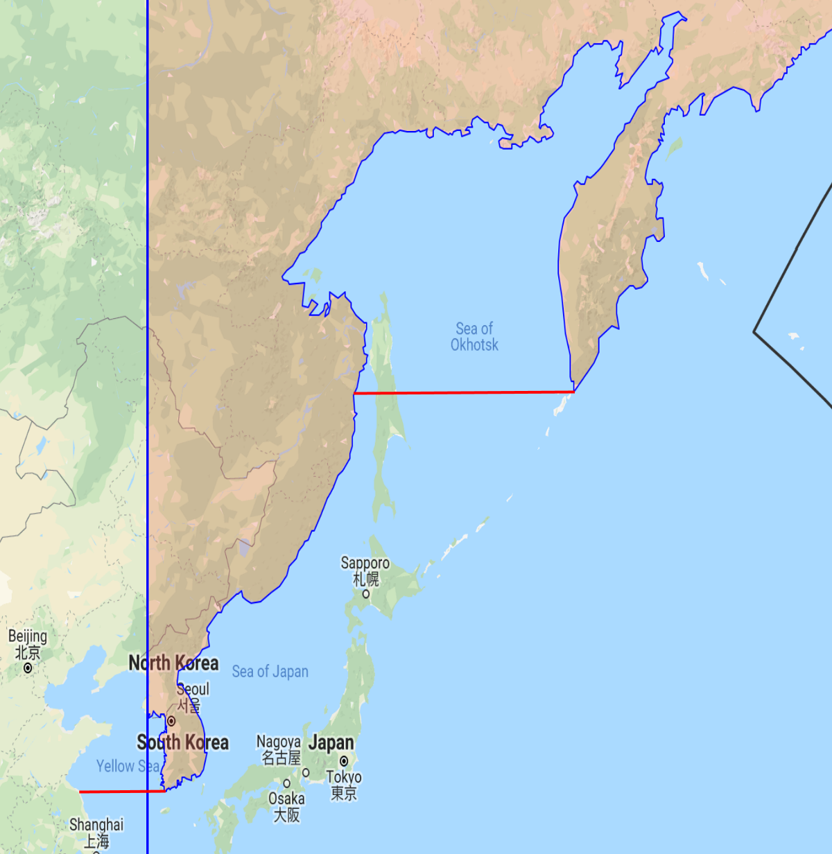
There are differing opinions whether an island in a bay would also be included in graira. Rabbi Yitzchok Meir Goldstein in his השבת בכל מושבותיכם (pages 85-88) brings the following opinions. Rabbi Shlomo Zalman Auerbach in הליכות שלמה (Moadim, vol. 2, page 70) is of the opinion that an island in a bay would be considered part of the land that partially surrounds it. In the same vein, (but not specifically in reference to a bay), Rabbi Moishe Sternbuch in מועדים וזמנים vol 7, ch. 236 mentions something similar (that the easternmost border of Australia would be a vertical line from north to south at the longitude of Brisbane, the eastern-most point of Australia). What is not clear is how large a bay can be. Rabbi Goldstein mentions that drawing a line from Siberia to Malaysia (thus creating a “bay”), would put Japan on the same side of the dateline as the Asian mainland. The Chazon Ish clearly stated that Japan was past the dateline. Presumably, Rabbi Shlomo Zalman Auerbach and Rabbi Moshe Sternbuch would agree that such a large area would not be included in graira. Given the lack of detail about the size of bays, it is possible that these poskim would only include very small bays (within the techum perhaps). It should be noted that Japan is only in the “bay” if you use a rhumb-line. Drawing a great circle line would result in Japan being out of the “bay”. Rabbi Dov Landau in the פשר חזון, and Rabbi Moshe Heinemann do not include bays as part of the graira zone. Rabbi Sternbuch was asked about bays by Rabbi Goldstein, and he agreed that according to the Chazon Ish, bays would not be included in graira, so Rabbi Sternbuch either reversed his earlier opinion, or he disagrees with the Chazon Ish’s opinion. There are related opinions that bays themselves do not drag islands within them into graira unless land to their east is part of graira. See Rabbi Leib Blum’s קו התאריך בכדור הארץ for details. For example the Sea of Okhotsk is to the west of the Kamchatka Peninsula. This means that they are of the opinion that you can’t have land to the east that is part of graira such as the Kamchatka Peninsula, and have Sea of Okhotsk and Sakhalin Island to the west of it that is considered past the line, (and back again to Siberia that is part of graira). The same would be the case in the portion of the Yellow Sea to the west of the Korean Peninsula and east of the Chazon Ish line, as well as the above mentioned Phillip Island and French island that are in the Western Port Bay near Melbourne. Bays such as Moreton Bay that includes Bribie and other islands near Brisbane, as well as Ulleungdo Island in the Sea of Japan would not be included in graira, since there is no graira land to the east of it.
Incheon International Airport and the Halachic Dateline
In January 2019, the Star-K held a Kashrus training seminar in Shanghai for mashgichim who live or work in Asia. Among the sessions, was a shiur about the halachic dateline by Rabbi Dovid Heber who shared the URL to my halachic dateline map with the participants. One of the mashgichim, Rabbi Yosef Wexler, who travels from Eretz Yisrael to Asia regularly, noticed a potential issue related to the Incheon airport, the main airport in South Korea (near Seoul). The airport is located on Yeongjong Island, that is connected to mainland South Korea by two long bridges. The island is within a Bay (formerly Chemulpo Bay), that is itself within the Yellow Sea that is itself a vary large bay. Ifgraira would not apply here (bridges and bays would not be considered a connection) and you followed the opinion of the Chazon Ish, the airport would observe Shabbos on local Sunday (the same issue faced in Japan). This impacts mashgichim who bypass Japan on Sundays, and regularly fly to Korea on flight KE958 on Motza’ei Shabbos from Israel on their way to China etc. The flight lands at about 3pm Sunday local time, when the airport may be observing Shabbos. It would also impact anyone else who plans on flying in or out of the airport between Motza’ei Shabbos and Sunday night.
Psak Halacha
Please consult a posek before relying on this for halacha lema’aseh. There are a number of opinions, and I will touch on a few of them.
As per Rabbi Heber, Rabbi Yonasan Weiner (a posek in Ohr Sameach) asked R’ Chaim Kanievsky about Phillip Island (that as mentioned above, has a bridge and is in a bay), and he answered that “it is צריך עיון“. Based on this, Rabbi Moshe Heinemann ruled that if someone is in the Incheon airport from shkiah on Friday (local day) until it gets dark on Saturday, one should keep regular Shabbos. From when it gets dark on Saturday night until it gets dark on local Sunday deoraisas should be avoided, but derabanans are permissible. This would permit most activities. The following quote in Rabbi Yitzchok Meir Goldstein’s השבת בכל מושבותיכם should be noted:
שמעתי מדודי הגאון רבי משה היינעמאנן שליט״א שאולי גבול היבשה הוא כשיעור תחום שבת מסוף היבשה
Yeongjong Island is at its closest 1,950 meters from mainland South Korea (from the eastern tip of the island to Wolmido, a former island that is now connected to land), and thus beyond tchum Shabbos. It is therefore not within the extended maritime graira zone. This applies to Incheon, but not the Yellow Sea. Rabbi Heber in his note to the Star-K mashgichim stated that melachos deoraisa should not be done within 35 minutes of landing since that is the earliest time the KAL958 flight passes the Chazon Ish line over the Yellow Sea. At this point according to the Chazon Ish it would be Shabbos. This was also mentioned by Rabbi Goldstein as a possible deoraisa. See below for more details.
Permissible Activities on Incheon Island on Sundays
There are many variables and variations in various melachos, so please consult a posek before relying on this for halacha lema’aseh.
Note: This list is only meant for Incheon airport on Sundays (from Motza’ei Shabbos until it turns dark on Sunday night) and other areas where a majority of opinions hold it is a weekday, but an accepted minority hold it is Shabbos. This list should not be used in any other locations or on a day that is accepted as Shabbos.
Traveling as a passenger to and from Incheon airport by plane or car. You do not have to worry about the 12 miltchum Shabbos.
Carrying your belongings more than 4 amos outside the airport, or carrying them into the airport – there is no reshus harabim deoraisa on the island
Walking in the airport including the use of escalators and moving sidewalks.
Triggering automatic sensor doors, sensors in bathrooms etc. (there no need to wait for someone else to activate it).
Scanning boarding or other passes (including to open electronic gates).
Going through security, taking muktzeh out of pockets, and passing through metal detectors.
Electronically signing into a lounge.
If a paper signature or writing is required, try to avoid it. If there is no other option, use your alternate hand (left for a righty, right for a lefty). An ambidextrous person can’t do shinuy by changing hands, and can’t sign or write.
Typing on a computer and typing or calling with cellphones is permissible, but the screen saver or the automated powering down of the monitor has to activate by itself to “erase” your writing. For power saving and security reasons, almost all computers will end up having a screensaver or a monitor power down and clear the screen. If this is not in place, and your “writing” will remain on the screen, it is more of a maaseh ksiva. Saving the document to your hard drive is permissible.
Problematic Activities During This Time
Opening a taxi door that causes the dome light to turn on (ask the driver to open your door, or have him open his door first, thus turning on the dome light)
Writing (with paper and pen).
Showers in the lounge should be avoided since there can be deoriasas involved.
Making coffee should be done the same way you would do it on Shabbos. Instant is fine, brewing fresh in a machine should not be done.
Rabbi Shlomo Miller in his approbation to the above mentioned Hashabbos Bechol Moshvosaichem, mentions that:
… והביא שטה אחת דכדי שיראה הוי בכלל אסטרליא וכן הי׳ דעתי נוטה [כמובן א״א להביא ראיות ברורות בזה] אולם יש להוסיף דלפי הגמ׳ בכורות נ״ד: עד ט״ז מיל הוי שעור כדי שיראה ויש אחרונים שהביאו מזה לגבי היקף מחיצות בשבת במחיצות הנעשות מאליהן דצריך שיהא העומד בתוכו רואה את המחיצות ע״כ עד ט״ז מיל יש מקום להסתפק אפשר שנגרר אחר אסטרליא.
This intuition (that he is unsure of) would potentially remove the questionable status of Incheon airport.
Rabbi Shmuel Meir Katz, a posek in Lakewood, discussed the Incheon airport question (focused on the fact that it is on a man-made portion of the island) in his Time Zone Shailos speech at the The Association of Kashrus Organizations’s 2018 Vaadim conference (24:50 into the recording). He said that a chaburah in Lakewood, NJ brought down a תוספתא נגעים פ״ו ה״ג that “בית שבים אין מטמאין בנגעים“. The גר״א has a girsa “בית שבים מטמאין בנגעים“. The ר״ש in נגעים פ׳ י״ב מ״א explains that
בית שבים: מדקתני בית שבים ובית שבספינה משמע דתרי מילי נינהו דשבים אפילו בנוי על גבי קרקע הים שהביאו אבנים וטיט ושפכו בים עד שנעשה כמין תל ובנו עליו בית אין מטמא בנגעים משום דכתיב ״ארץ״ ולא ים
This implies that the only questionable status is for נגעים, but otherwise, man-made land would have the status of natural land. Rabbi Katz holds that the bridge itself would connect the island and give it the same halacha as the mainland. It should be noted that Rabbi Katz also discussed the issue of The Sea of Okhotsk. His opinion is that the line follows the contour of the land, and the Sea of Okhotsk and Sakhalin Island would not be included in graira, but mentioned that Rabbi Leib Blum felt that it should be included due to it being to the west of land that has graira.
Rabbi Mordechai Kuber in his upcoming book, Crossing the Dateline (published a year after this was posted) strongly feels that there is no problem in Incheon airport on Sundays due to it being in a bay (that is in itself a safek). The question of the bridges, its proximity to land, and the many sandbars between it and the land make it at most a sfaik sfaika, which most poskim should agree is not an issue even according to the Chazon Ish. This sfaik sfeka is in addition to the other opinions who do not agree with the Chazon Ish, and are of the opinion that Incheon is not east of the halachic dateline, and therefore Saturday is Shabbos in Incheon, and not Sunday.
Rabbi Yitzchok Meir Goldstein in a letter to me mentioned that there is a possibility of a deoraisa in flying on a flight that is completely or partially on Shabbos
… this is comparable to one who boards a plane which takes off before Shabbos and lands after Shabbos, which, as the Shailos U’Teshuvos Minchas Yitzchok 2:106, the Shailos U’Teshuvos Tzitz Eliezer 1:21 and the Shailos U’Teshuvos Shraga HaMeir 7:27 write, involves an issur d’oraysa transgressing the chiyuv of “shabosson” which is not fulfilled while on an airplane ride. (However, it could be that there is a sevara to say that there is a difference in the d’oraysa of “shabosson” between flying on an airplane for the whole Shabbos and flying over the Yellow Sea for a short time …). If, indeed, this involves an issur d’oraysa, this creates a problem not only for people who follow the opinion of the Chazon Ish with regard to the dateline, but even for people who refrain from issurim d’oraysa on the Shabbos of the Chazon Ish. If so, regardless of whether or not the sevara of graira applies to Incheon Airport, I would think that people should still not be flying to that airport on Sunday. Second of all, even if I am mistaken in the above comparison and there is no issur d’oraysa to fly over the Yellow Sea while it is Shabbos in the Yellow Sea, it would be worthwhile for you to mention in your article that at least while the airplane is flying over the Yellow Sea one should certainly be careful not to perform any melacha d’oraysa such as writing. I am not trying to offer a psak about these points, but I think there is reason to consult with a poseik whether these issues need to be mentioned in your article.
It should also be noted that on page 83 of השבת בכל מושבותיכם, Rabbi Chaim Kanievsky is quoted with a different psak than the one quoted above by Rabbi Yonasan Weiner. Rabbi Goldstein sent the following question to Rabbi Chaim Kanievsky
שמעתי שבחוף הים של אוסטרליה יש גשרים ובנינים שנבנו בידי אדם שיוצאים מן היבשה לתוך קצה הים, האם גם בנינים אלו וגשרים אלו המחוברים ליבשה נגררים אחר שאר ארץ אוסטרליה או רק הארץ שנעשה שם בידי שמים ולא מה שניתוסף בידי אדם בתוך הים?
Rabbi Kanievsky replied with his typical brevity
נגררים
I would like to thank Rabbi Dovid Heber, Rabbi Shmuel Meir Katz, Rabbi Yitzchok Meir Goldstein, Rabbi Mordechai Kuber, My father-in-law R’ Feivel Muller and my wife for reviewing this article. This article is published in memory of my mother-in-law Mrs. Helen Muller חיה בת ר׳ יצחק הכהן ע״ה.