El Al’s Latest Zmanim App. Note the latitude and longitude on the display as well as the version number.While there have been many technical updates to El Al’s in-flight zmanim app since it rolled out, none included changes to the visual user interface. In February, El Al rolled out a long awaited update by FlightPath3D to the user interface based on feedback received since the initial system was rolled out. The new UI has many enhancements including:
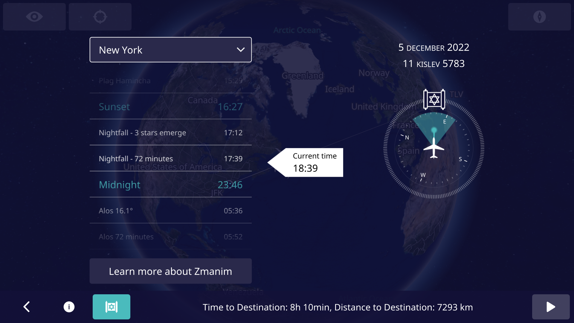
Displaying the latitude and longitude on the main screen to allow people to more easily validate the accuracy of zmanim calculations and simplify bug reporting. This feature involved a security review by El Al. To enhance reporting even further, the app version is displayed on the main screen. I am not aware of any software that shows the version on the main app screen, but we are doing what we can to help resolve any potential issues, and knowing the version number can help. Since feedback is often in the form of a picture of the screen, displaying the aircraft location and version number on the screen simplifies debugging issues.
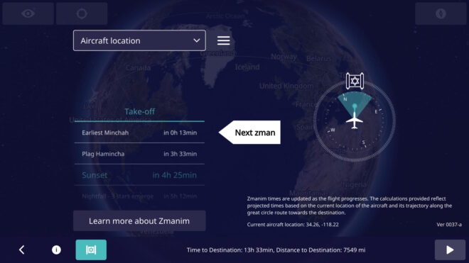
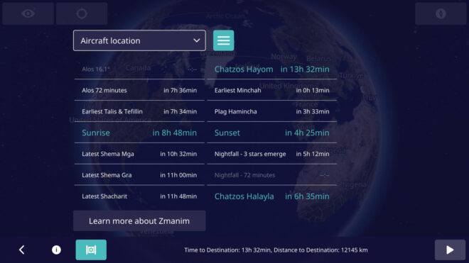
A UI toggle to show a more extensive list of zmanim (not just a few past and upcoming ones).
Avoid showing the zmanim screen before takeoff (projections on the ground are too inaccurate, since the system has no idea when it will take off). Even showing zmanim for specific cities prior to takeoff was shelved in a UX review since it would likely confuse users who would think that it reflected the flight zmanim. The icon for displaying zmanim shows up as soon as the flight is underway.
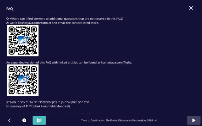
Minor FAQ changes, including the addition of QR codes to simplify contacting us to report issues. Thank you YCS for the suggestion.
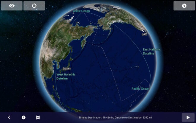
The Halachic Datelines (the Chazon Ish and Rav Yechiel Michel Tucazinsky) were added to the flight map. Note that graira / גרירה is used in the Chazon Ish (west) date line, but not Rav Tucazinsky’s (east) date line, since he was seemingly מסופק / unsure about concept. This change was a mapping update, and not a zmanim app update.
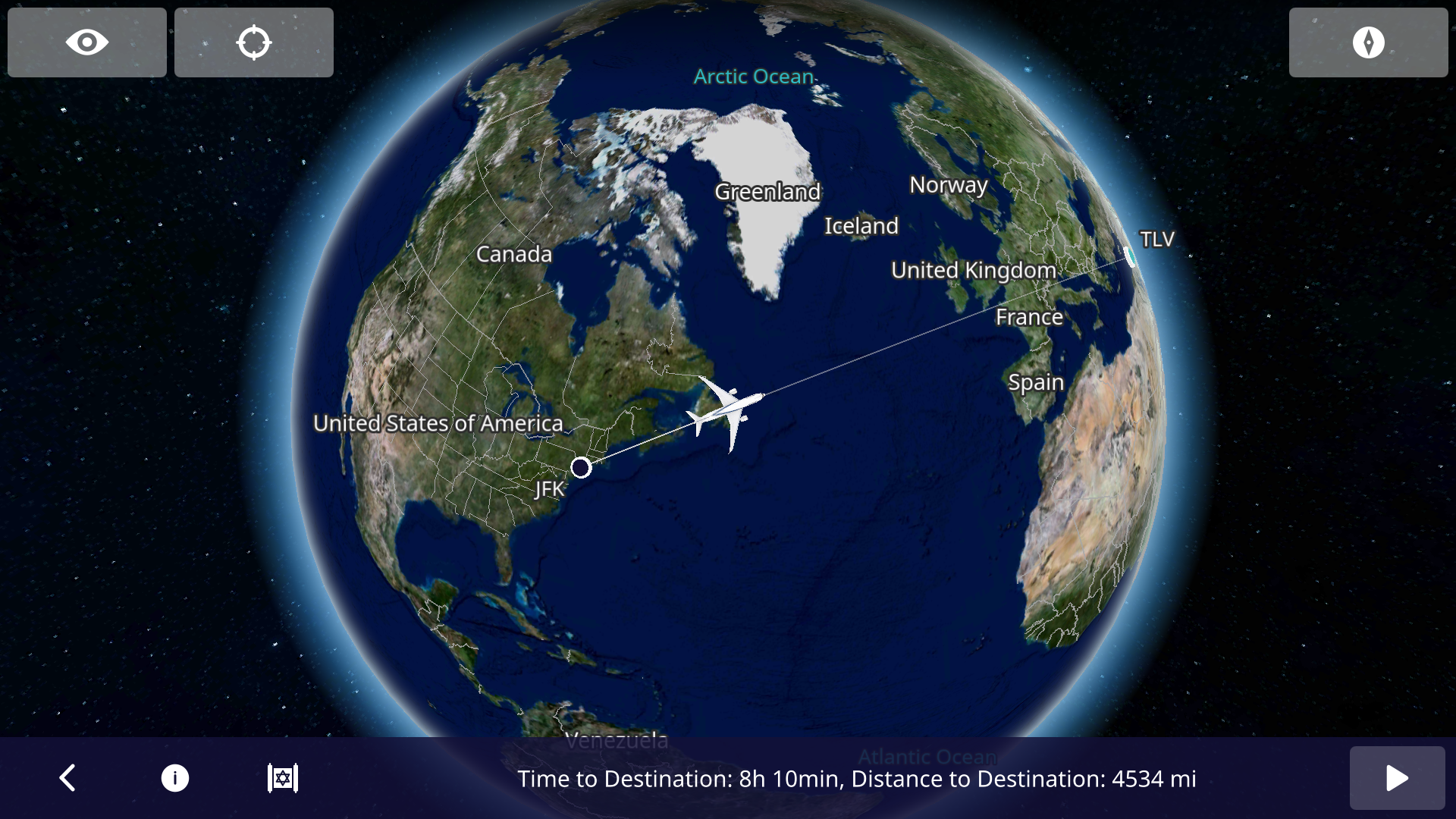
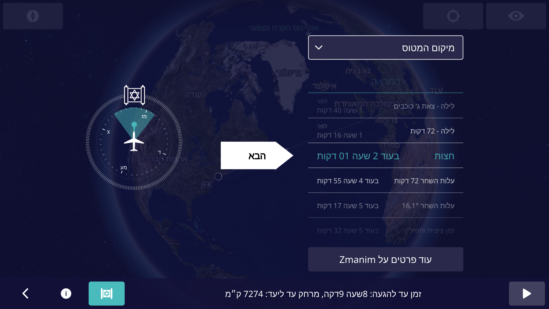
In an earlier Inflight Zmanim Calculations – Why So Complex? post, I outlined the complexity of calculating zmanim for flights. Back in Aug 2022, Dan’s Deals posted the exciting news that Zmanim were added to El Al’s flight entertainment system. This had not been formally announced by El Al at the time since the app was really in an (unannounced) alpha/beta testing phase. A careful examination of the screenshots by members of the #zmanim channel in the Frum Software Developers Slack, showed that it was powered by the KosherJava zmanim library. It should not have been surprising that it was found and used without my knowledge, since it is a free, well documented and easy to use open source library. After a number of issues with the zmanim app were reported to me (I want to thank all of those who took the time to track me down to report the issues), Rabbi Dovid Heber reached out to El Al, and Tal Kalderon, the head of El Al’s Inflight entertainment & Connectivity team reached out to me for assistance. This lead to meetings with Boris Veksler the CEO of FlightPath3D who integrated the KosherJava zmanim code into their flight maps as an optional module that El Al is using.The FlightPath3D in-flight mapping app on El Al with the zmanim app Magen Dovid icon on the bottom leftBoris made it a personal mission to perfect the product and a series of fixes were deployed until the final release of the Prayer Room / Mesivta Derakia app was deployed on El Al aircraft on 5 Feb, 2023. At this point, the app started displaying accurate zmanim. Boris and the FlightPath3D team put a lot of effort into perfecting it into an easy-to-use app. To ease understanding of zmanim on flights that cross time zones, the app shows countdown times to the upcoming zmanim.The El Al Zmanim app showing the default current aircraft location zmanim For example, El Al flight LY 26 from New York to Israel departing at 9pm will show a countdown to chatzos/midnight, alos hashachar (two variants) and later zmanim (such as misheyakir, sunrise, etc.), displaying a countdown, with the number of hours and minutes to upcoming zmanim. Zmanim are calculated based on the plane’s current location, speed and the flight path. Since headwinds and tailwinds (as well as in-flight route changes) can significantly change the time that zmanim will be reached, the times to the upcoming zmanim are recalculated multiple times a minute. This significantly reduces the challenge to passengers, since precalculated zmanim do not come close to real time calculations on the flight. The app also shows a compass with the bearing to Yerushalayim / Jerusalem (map). The FAQ that is part of the zmanim app on the aircraft appears in a hyperlinked version at El Al In-Flight Zmanim FAQ on this site. The app defaults to the Aircraft location but can be changed to show zmanim for multiple international citiesThe El Al zmanim app displaying zmanim for New York, displayed in the time and time zone of those cities. The app works in both English and Hebrew, based on the language selected in the flight entertainment system. A thank you goes to R’ Chaim Keller of the indispensable Chai Tables project for allowing the development team access his flight path algorithms. The FAQ would not have been possible without help of translators and copy-editors.The El Al Zmanim app in Hebrew A special thanks to Effie Freiner from Lakewood for the Hebrew translation (the “Yeshivish” Hebrew posed its own set of challenges), and to my wife and Dovid Nachfolger for clarifying the language and grammar in the English FAQ. I spent time with Rabbi Dovid Heber, Rabbi Dovid Braunfeld, Rabbi Yisroel Harfenes and Reb Solly Tropper reviewing the various complexities of calculating in-flight zmanim before the app left the βeta stage and went live.
Developing Software for Aircraft
Developing apps for use on an airliner has a series of challenges, in particular for in-flight entertainment (IFE) systems. It is a complex process that requires a deep understanding of the aviation industry and the systems onboard the aircraft.
First, the hardware hosting the apps goes through stringent safety certifications and has to pass a series of requirements. These include being isolated from any cabin and aircraft controls. The most they can do is access the flight management system (FMS) in read-only mode, with no ability to push data to the FMS. These certifications are done for each aircraft configuration and can take a year or more to complete.
Software and the associated apps also follow similar certification processes. The software must be designed to work seamlessly with any IFE systems already in place on the aircraft. Thus, it has to adapt to new and older hardware and operating systems and understand and adapt to idiosyncrasies in the data provided by the FMS. FlightPath3D is a leading provider of interactive mapping software for IFE systems. This type of software provides passengers with real-time information about their flight’s location, altitude, and speed, as well as other relevant data such as the estimated time of arrival and the distance to the destination. This made FlightPath3D a natural vendor for the zmanim work. FlightPath3D has a wealth of experience in developing high-quality software solutions that meet the needs of airlines and passengers and adapt to the particular hardware installed onboard.
לז״נ אבי מורי הרב יצחק אריה בן ר׳ ברוך הירשפלד ז״ל. נפ׳ י׳ אדר ב׳ תשפ״ב. In memory of my father R’ Yitzchok Hershfeld (Montreal).
לז״נ חמי ר׳ שרגא פייבל בן ר׳ שלמה יהודה מילר ז״ל. נפ׳ ט״ו אייר תשפ״ג. In memory of my father-in-law R’ Feivel Muller (Brooklyn / Lakewood).