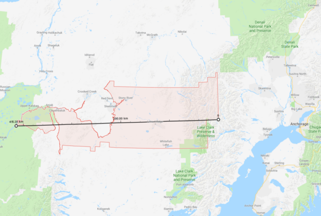
99557 ZIP code area (the largest in the USA)There are many zmanim services and apps that use ZIP codes as a location finder for calculating zmanim. While very convenient, there is a potential pitfall in using ZIP codes for geolocation. In general, ZIP code geolocation services will provide the center of the ZIP code and zmanim apps calculate zmanim for that location. The issue arises with large ZIP code areas mostly found in rural areas. Take the following two extreme cases that have very large ZIP code areas. ZIP code 89049 for rural Tonopah, NV, is 195 km (121 mi) from east to west. The eastern boundary of this non-contiguous ZIP code has a longitude of -115.417°, while the western boundary is -117.625°. This means that there are 2.2° of longitude between the eastern and western borders of this ZIP code. The earth rotates 1 degree every 4 minutes, so zmanim at the eastern and western edges of this ZIP code are approximately 8.8 minutes apart. Using the typical center of the ZIP based calculations would mean that zmanim would be about 4.4 minutes different at the edges compared to the center. Moving to something a bit more extreme, is the case of ZIP code 99557 of Aniak, Alaska and its surrounding area. This ZIP code is 415 km (258 mi) from east to west. The longitude of the eastern edge of the ZIP code is -153.032°, and the western edge is -160.783°. Being farther north and therefore having shorter distances between degrees of longitude, this ZIP code stretches across 7.7° of longitude. The zmanim difference from the center to the edges of this ZIP code is 15 and a half minutes (31 minutes across the ZIP). While it is indeed rare to have such large distances, there are 193 US ZIP codes that are over 1° of longitude wide, meaning that the zmanim difference for these ZIP codes are at a minimum 4 minutes apart, or 2 minutes off from the center. There are 1,463 or 4.4% of all ZIP codes with 0.5° or greater distance between east and west (a minimum of a 2 minute zmanim difference between the east and west zide of the ZIP code). zmanim software developers should be aware of this, and take care to alert users of possible inaccuracies when using large ZIP code areas, or require addresses or more specific location information for large zip codes. Let’s contrast the above with Lakewood, NJ. With 0.107° of longitude from east to west, zmanim are 24 seconds later on the west side (the intersection of New Central Ave & N Hope Chapel Rd) than the east side (Shinn Cranes, 1600 Ocean Ave). New York City is larger, and from the western edge of Staten Island to the edge of Glen Oaks, the eastern edge of Queens there is a 2 minute and 11 second difference in zmanim. See the Calculation of Zmanim VS Other Sites post for additional related material. I thank Avraham David Gelbfish for generating the ZIP code longitude range for all 33,093 ZIP codes from the US Census BureauZIP code shape files.