
FAQ: How Much Earlier is Sunrise on Mount Everest Due to Elevation?

Sunrise over Everest

Question:

How Much Earlier is Sunrise on Mount Everest Due to Elevation?

Answer:

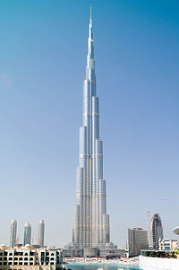
The greatest sunrise and sunset elevation effect on Earth is on Mount Everest (at 27.988° N, 86.925° E as seen on the Direction to Yerushalayim Map). With an elevation of 8,848 Meters (29, 029 feet), sunrise would be up to 15 minutes and 31 seconds earlier on Mount Everest than at sea level. The range of the effect is from 15 minutes and 31 seconds on June 22nd, to a “low” of 13 minutes 41 seconds earlier on March 18th. Being in a large mountain range with obstructed horizons, it is likely never actually seen that early. In addition to questions about mountains, every few months I get asked about how much earlier sunrise/set can be seen in skyscrapers. There are various halacha questions as to whether this actually affects zmanim that I will mention later. Here are some raw numbers. Burj KhalifaBurj Khalifa (at 25.197° N, 55.274° E as seen on the Direction to Yerushalayim Map) is the tallest building in the world. With a height of 828 m (2,717 ft), visible sunrise to someone standing on top of the crown (something unrealistic) on June 22nd would be at 5:24:56 AM versus 5:29:31 AM on sea level, a difference of 4 minutes and 35 seconds. Sunset would be 7:16:35 PM versus 7:12:00 PM at sea level, a difference of 4 minutes and 35 seconds. A more realistic scenario would be the visibility sunrise on the highest floor (the 160th), an elevation of 672 m (2,204 ft) at 5:25:23 AM, a difference of 4 minutes and 8 seconds earlier than sea level. Sunset on the 160th floor would be 7:16:08 PM, or 4 minutes and 8 seconds later than at sea level.
As far as the halacha being affected by the elevation of buildings, the Baal Hatanya seems to indicate that tall buildings would make sunset later. See Yisroel vehazmanim ישראל והזמנים Vol II, page 910. In the Shraga Lachaim שרגא לחיים footnotes Rabbi Harfenes states that

ויש להוסיף שהוא דבר תמוה לומר דעד שלא נבנו הבנינים הגבוהים היה זמן שבת התלוי בשקעה”ח (שקיעה ראשונה להגאנים ושקיעה שניה לר”ת) מוקדם, ולאחר שנבנו יש לאחר הזמנים, ועד עכשיו שהיו בניו יארק הבנינים התאומויות (טווין-טאוע”ר בלע”ז) שכל א’ מהם היה בת ק”י קומות היה זמן השקיעה מאוחר, ועתה לאחר שהפילו והרסו אותם רשעים וזדים ארורים ימ”ש חזר הדבר לקדמותו להקדים זמן השקיעה.
Calculating the Bearing/Direction to Har Habayis Using the Zmanim API

Vintage Map with CompassAn earlier “Bearing to Yerushalayim and Zmanim Map” post demonstrated the use of JavaScript to render the bearing to Har Habayis on a Google Map. A more detailed follow-up post “Technical Information about the Bearing to Yerushalayim Map” dealt with detailed technical information on these calculations. The main Bearing to Yerushalayim and Zmanim Map page usually has the most up to date information on the subject. What was not detailed in previously published posts and pages was that most of the calculations available via JavaScript are now in the core Zmanim API. Available since the July, 2008 beta 2 release of version 1.1 is the ability to bearings/directions using both the great circle and rhumb line methods in Java. The GeoLocation Object was modified to calculate the great circle bearings (both initial and final), and rhumb line bearing from any GeoLocation Object to another. In addition, distance calculation between the two points using both of these line types is supported. What was not ported from the JavaScript version was the less accurate Haversine formula, or the simpler spherical law of cosines algorithms that yield identical results. Instead, the Zmanim API uses the far more accurate Vincenty formulae using the WGS84 geoid model of the earth. Published by the geodesist/mathematician Thaddeus Vincenty, it is said to be accurate to about one-half millimeter, more than adequate for our calculation. The code in the API is a Java port of the previously published, slightly modified version of Chris Veness’s JavaScript implementation . Below is a simple Java example of generating bearing and distances.

/**
 * This program demonstrates how to calculate bearing to Yerushalayim
 * using the kosherjava.com Zmanim API. Both the great circle and
 * rhumb line method are shown
 * To compile, ensure that the Zmanim Jar is in your classpath.
 */
import com.kosherjava.zmanim.util.GeoLocation;
import java.util.TimeZone;

public class BearingToYerushalayim{
	public static void main(String [] args) {
		GeoLocation lakewood = new GeoLocation("Lakewood, NJ", 40.09596, -74.22213, 0, TimeZone.getTimeZone("America/New_York"));
		GeoLocation harHabayis = new GeoLocation("Har Habayis", 31.77805, 35.235149, 0, TimeZone.getTimeZone("Asia/Jerusalem"));

		double greatCircleInitialBearing = lakewood.getGeodesicInitialBearing(harHabayis);
		double greatCircleDistance = lakewood.getGeodesicDistance(harHabayis);

		double rhumbLineBearing = lakewood.getRhumbLineBearing(harHabayis);
		double rhumbLineDistance = lakewood.getRhumbLineDistance(harHabayis);

		System.out.println("Great circle initial bearing: " + greatCircleInitialBearing + " degrees ");
		System.out.println("Great circle distance: " + greatCircleDistance / 1000 + " km");

		System.out.println("Rhumb line bearing: " + rhumbLineBearing + " degrees");
		System.out.println("Rhumb line distance: " + rhumbLineDistance / 1000 + " km");

	}
}

Technical Information about the Bearing to Yerushalayim Map

Vintage Map with CompassI have been asked a number of questions recently about the directional accuracy of the Bearing to Yerushalayim and Zmanim Map calculations. The rhumb line calculations are very straight forward, and I will not spend much time on it in this article. As a side note, for those interested in the subject, I would like to mention that Rabbi Gavriel Goetz recently published a very comprehensive pamphlet Gevuras Moishe on the subject and it is well worth reading.
My original calculations and implementation of the great circle route (geodesic line) used simple spherical trigonometry to calculate the initial bearing (and distance) based on a sphere using an authalic mean radius of 6371 km. These calculations were very similar to the method used by Rabbi Yehuda Herskowitz’s article in Yeshurun volume III page 586. This model of the earth is more than accurate enough for these calculations (you would need a very accurate “nose alignment” and the total lack of shuckling to even get within a degree of being correct). Google Maps API, Yahoo Maps and Microsoft’s Live Maps for simplicity sake, all use very similar calculations as mentioned in the cfis blog quoting Morten Nielsen

Google Maps / Virtual Earth / Yahoo Maps(?) all use a spherical datum based on WGS84. That is, it has the same center, orientation and scale as WGS84, but has no flattening. The radius of the sphere is the same as the semi-major axis of WGS84 (6378137 meters).

Using a sphere, all the above-mentioned mapping APIs use spherical law of cosines formula for the calculations, that yield an identical result to the more complex Haversine formula.

Curious how accurate these calculations really are, being based on a perfect sphere and not the oblate ellipsoid/spheroid that the earth actually is, I started looking into the subject a little more. The most accurate current geoid model of the earth is the WGS84 model. The geodesist/mathematician Thaddeus Vincenty published the Vincenty formulae for this type of calculation that is said to be accurate to about one-half millimeter, more than adequate for our calculation. Chris Veness implemented this formula in JavaScript and released it under the LGPL, making it very simple to use. I slightly modified his work to allow easier interaction with the Google Maps API. The implementation that I used when I finally published the map on December 30, 2007, uses the Vincenty formula with the WGS84 geoid model (the Vincenty formula can easily be used with different goeiod models). The table below shows a comparison of the results for the initial bearing and distances of the different calculations based an a Lakewood, NJ (latitude: 40.095965°, longitude: -74.22213°) to Har Habayis (latitude: 31.77805°, longitude: 35.235149°) example.

Calculation Method Initial Bearing Distance
6,371 km (authalic mean radius) sphere using spherical trigonometry 53.86555° 9224.67442 km
Google Maps API 6,378.137km (WGS84 equatorial mean radius) sphere using spherical trigonometry N/A 9235.00819 km
Vincenty formula using a WGS84 geoid 53.81786° 9244.61686 km
rhumb line 95.37152° 9891.16074 km

Bearing to Yerushalayim and Zmanim Map


Did you ever find yourself unsure of the correct bearing (direction) to Yerushalayim (Jerusalem)? The new Zmanim/Bearing to Yerushalayim map will help you find it very easily. The map draws two lines from your location to Yerushalayim. The blue line uses the commonly used (לבוש Levush and others) rhumb line (a straight line on a Mercator projection map), while the green line shows the great circle route (Rabbi Aviad Sar Shalom Basilea הרב אביעד שר שלום באזילה in his אמונת חכמים Emunas Chachamim and others) on a map. While it appears that the circle line is not a straight line, on a globe, the shortest (and straightest) line between two points follows the great circle route. Future posts will detail the technical aspects of the work involved. For additional information of the correct bearing for tefila, see Rabbi Yehuda Herskowitz’s article in Yeshurun volume III page 586 and Rabbi Gavriel Goetz comprehensive pamphlet Gevuras Moishe on the subject.

How to Use

Find your exact location on the map by dragging the marker to your exact location or by clicking anywhere on the map. You can also click on the search button and enter your location (such as “Lakewood, NJ” (the default), “Vilnius, Lithuania”) or just enter a zip code (Canadian or British postal codes work as well) to zoom in on your location. Changing to satellite view and zooming in farther will make the job easier (assuming that you can identify your roof). Once the red marker is centered on your location, click the red marker to show your exact latitude, longitude and bearing to Yerushalayim in an info window. There are two additional tabs that show today’s zmanim. You can click on the “Link” button to refresh the page with the URL that contains coordinates to the currently displayed map with its zoom level so that it can be bookmarked or emailed.
I would like to thank Rabbi Yehuda Herskowitz for his excellent article and additional information that he provided.

Known Issues

Google Maps API Bugs (All Fixed by Google)

  1. Zmanim data sometimes fails to show in Firefox. This seems to be a bug in the Google Maps API when dealing with synchronous AJAX calls.
  2. Locations close to 180° from Yerushalayim (Alaska is a good test case) sometimes shows an incorrect rhumb line bearing (though the circle route shows correctly). The information in the info widow is correct. This is a known issue with the Google Maps API.
  3. Related to the above issue, sometimes the lines are drawn a “world away” and horizontal scrolling of the map is required to see the lines. Again this is a known Google Maps issue.

To Do (related to Zmanim)

  1. Support Daylight savings time (supported by the timezone webservice used, but not yet implemented in the map).
  2. Link to a yearly calendar.
  3. Elevation lookup (already available in the yearly calendar).
  4. Allow changing of the date.

Note that it is not clear that the Levush was of the opinion that the rhumb line should be used.

Zmanim Calendar Generator Now using Google Maps

Vintage Map with CompassThe Zmanim Calendar Generator now has a simple way to look up longitude and latitude information using the Google Maps API. To use this feature, click on the Google Maps icon to display the map (location centered on Bais Medrash Gevoha in Lakewood), find the location that you want to generate zmanim for, and click that point in the map. This will update the longitude and latitude fields in the form. The Google API was pretty straight forward and simple. At the same time, I tried to integrate an elevation lookup. Google does not provide elevation information, but I attempted to look it up using a webservice. This seemingly simple task was not very straight forward. The approach was to grab the SOAP response from the REST style elevation webservice made available by Jonathan Stott. My plan was to do this all via the client sided XML parsing. The first issue encountered was browser security that does not allow cross-domain loading of XML documents (By the way this was not using XMLHttpRequest, but the same security restrictions apply). This was solved by a simple PHP page that was just a proxy for the call. That done, I managed to get it to work in IE, but it crashed the browser every second call or so. The crashing was solved by adding a small delay. I never managed to get it working in Mozilla. I later tried to use the existing Google Maps API to load it, but never got it working. I commented out all elevation code and will get to that part at some future date. I also removed the non-decimal longitude and latitude option. I hope this will be useful.