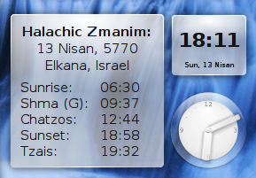
Moshe Wagner recently released ZmanimPlasma for the Linux platform. This KDEPlasma desktop widget displays the Hebrew date and zmanim on a Linux desktop. The zmanim calculations use Moshe’s C++ portZmanim CLI wrapper that enables a C++ program to call the Java Zmanim API. There are no current plans to make this widget available on any other platform. It can be downloaded from the Luach project download page. Moshe has in the past used the Zmanim API for use in Linux and some cross platform projects. These include the above mentioned Zmanim CLI, and Zmanim GUI that uses the ZmanimCLI.
Updated on 4/13/2010 ג׳ אייר תשע״ג to reflect information from Moshe explaining that this was not a port.
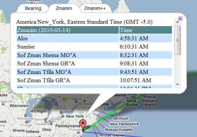
The availability of the Bearing to Yerushalayim and Zmanim Map was originally announced on December 30, 2007. At the time there were a number of bugs related to the Google Map API. These bugs were reported to Google and eventually fixed. Since that time, the only change was a minor JavaScript fix for IE. The Bearing to Yerushalayim worked, but the zmanim tabs had a major issue because the timezone calculated was done based on the user’s current browser timezone. This made it tricky to check zmanim in a different location or timezone than the user’s current timezone.I recently updated the map to look-up the actual timezone of the latitude and longitude selected by the user. This was implemented by doing a look-up at the geonames.orgtimezone web-service. The timezone is passed to the Zmanim API and used to generate the XML output of a list of daily zmanim that is displayed in the map. Since the Olson timezone database changes a few times a year, there will almost certainly be cases where the proper timezone can’t be determined. Some of these are changes of timezone names, such as the change from Asia/Calcutta to Asia/Kolkata (my host will not run the TZ Updater tool). In these cases, a simple mapping between the old and new was added to the map. In cases where the timezone can’t be determined the timezone will default to GMT. Ocean locations within 10 km of land will use the closest landmass, but anywhere beyond 10 km will default to GMT. One issue with using the geonames.org webservice, is that when it is down, the map will timeout. I experimented with various ways of dealing with this, but unless my host updates the Java version from 1.4, they are too complex to use at this time.
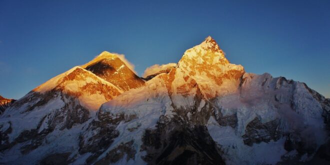
How Much Earlier is Sunrise on Mount Everest Due to Elevation?
Answer:
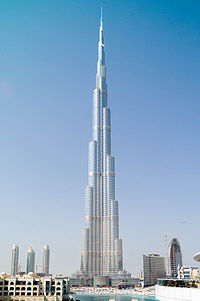
The greatest sunrise and sunset elevation effect on Earth is on Mount Everest (at 27.988° N, 86.925° E as seen on the Direction to Yerushalayim Map). With an elevation of 8,848 Meters (29, 029 feet), sunrise would be up to 15 minutes and 31 seconds earlier on Mount Everest than at sea level. The range of the effect is from 15 minutes and 31 seconds on June 22nd, to a “low” of 13 minutes 41 seconds earlier on March 18th. Being in a large mountain range with obstructed horizons, it is likely never actually seen that early. In addition to questions about mountains, every few months I get asked about how much earlier sunrise/set can be seen in skyscrapers. There are various halacha questions as to whether this actually affects zmanim that I will mention later. Here are some raw numbers. Burj Khalifa (at 25.197° N, 55.274° E as seen on the Direction to Yerushalayim Map) is the tallest building in the world. With a height of 828 m (2,717 ft), visible sunrise to someone standing on top of the crown (something unrealistic) on June 22nd would be at 5:24:56 AM versus 5:29:31 AM on sea level, a difference of 4 minutes and 35 seconds. Sunset would be 7:16:35 PM versus 7:12:00 PM at sea level, a difference of 4 minutes and 35 seconds. A more realistic scenario would be the visibility sunrise on the highest floor (the 160th), an elevation of 672 m (2,204 ft) at 5:25:23 AM, a difference of 4 minutes and 8 seconds earlier than sea level. Sunset on the 160th floor would be 7:16:08 PM, or 4 minutes and 8 seconds later than at sea level. As far as the halacha being affected by the elevation of buildings, the Baal Hatanya seems to indicate that tall buildings would make sunset later. See Yisroel vehazmanim ישראל והזמנים Vol II, page 910. In the Shraga Lachaim שרגא לחיים footnotes Rabbi Harfenes states that
ויש להוסיף שהוא דבר תמוה לומר דעד שלא נבנו הבנינים הגבוהים היה זמן שבת התלוי בשקעה”ח (שקיעה ראשונה להגאנים ושקיעה שניה לר”ת) מוקדם, ולאחר שנבנו יש לאחר הזמנים, ועד עכשיו שהיו בניו יארק הבנינים התאומויות (טווין-טאוע”ר בלע”ז) שכל א’ מהם היה בת ק”י קומות היה זמן השקיעה מאוחר, ועתה לאחר שהפילו והרסו אותם רשעים וזדים ארורים ימ”ש חזר הדבר לקדמותו להקדים זמן השקיעה.
The Zmanim API 1.2 was released today. The only change in this release is the removal of elevation as a factor in the calculation of all zmanim besides sunrise and sunset. Updated JavaDocs now reflect these changes. Please see the Elevation Now Only Impacts Sunrise and Sunset Calculations in the Zmanim API post for additional information.
I would like to thank the various people who contacted me on the subject.
The main download is the Zmanim 1.2 release zip file that includes source files and JavaDoc documentation. Also available for download (included in the above zip file) is the main zmanim-1.2.jar. The zmanimAstronomical-1.1.jar that only includes the AstronomicalCalendar was not impacted by this change, but the version has been updated to zmanimAstronomical-1.2.jar for consistency. Additional detail on the downloads can be seen on the Zmanim Download page
Note: On Aug 1, 2018 – כ״א אב תשע״ח, elevation became optionally available as a factor in most zmanim calculations. The KosherJava Zmanim library was updated to optionally allow using elevation as an attribute that will adjust most zmanim via the ZmanimCalendar.setUseElevation(boolean). There are some zmanim such as degree-based zmanim that are driven by the amount of light in the sky and are not impacted by elevation. These zmanim intentionally do not support elevation adjustment. The following is the original post.
I have received a few emails over the past year or so about the use of elevation as part of the calculation of various zmanim in the API. All releases of the zmanim API up to the current 1.1 release, use elevation to affect the calculation of all sunrise/sunset based zmanim. While my footnote on the Zmanim Calendar Generator page stated that this only impacted sunrise and sunset (quoting the Yisrael Vehazmanim and Calendrical Calculations), in practice all zmanim calculated based on sunrise and sunset were affected by elevation. An example of a zman that used elevation in 1.1, but will no longer in 1.2, is the calculation of Sof Zman Krias Shema according to the GR”A. The soon to be released version 1.2 limits the impact of elevation to sunrise and sunset only. The Zmanim Calendar Generator page already uses the latest changes to the code. To facilitate changes by ports of the API, a list of changes to the source code of the ZmanimCalendar.java and ComprehensiveZmanimCalendar.java is available in a diff file (a proper Unix diff/patch is not available at this time). The diff files were generated prior to updating the JavaDocs to simplify the work of anyone modifying ports of the Zmanim API. Detailed sources for not using elevation for anything besides sunrise and sunset can be found in פרק ב׳ סעיף ט׳ (pages 186-187) in the second edition of Zmanim Kehilchasam זמנים כהלכתם by Rabbi Dovid Yehuda Bursztyn.