Inflight Zmanim Calculations – Why So Complex?

Airline ZmanimDetermining zmanim times while on an airline flight is rather complex compared to calculating it for a fixed location. Some of the complexity involves:

  • Where you are currently located
  • Your Speed
  • Direction of travel / flightpath

The above 3 variables impact the calculation of what the zmanim are in your current location and where you will likely be when various zmanim are met.

Surprisingly, the hardest part is figuring out your current location. The shortest point between 2 points on the globe is the great circle route. Though it is the shortest path, airliners rarely fly this way. To take advantage of prevailing winds such as the Gulf Stream, or to avoid bad weather, airlines often fly much longer routes and as a passenger you often do not know exactly where you are.
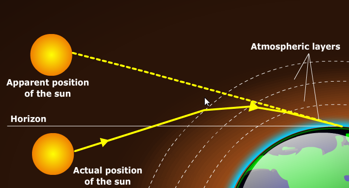
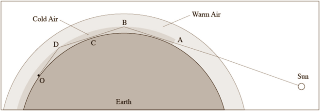
Yes, the airline shows you a nice location map, but getting your exact coordinates from the map is not something that they usually supply. From a practical perspective, many people on domestic and short international flights will manage to figure out davening times by themselves. As a general rule of thumb, it is time for Shacharis when the sun rises and time for Maariv when it gets dark. Please keep in mind that most poskim are of the opinion that we use zmanim at sea level elevation, or ground level, and not the 37,000 foot elevation of the flight. This elevation results in a difference of approximately 20 minutes in sunrise and sunset times. Not sure when Mincha time is? Wait until shortly before sunset. Just keep in mind that when flying due east (such as a flight from NY to Israel), you are flying in the opposite direction as the sun and the time for davening is compressed. While you may expect sof zman krias shema to be 1/4 of the way into the day, in this case the davening window is compressed into a much shorter time. The real complexity is in flights that cross the halachic dateline, polar flights and to a lesser degree, cross-Atlantic and Pacific flights. This article will not delve into the halacha of in-flight zmanim, but solely on the technical aspects of figuring out the zmanim times.

GPS

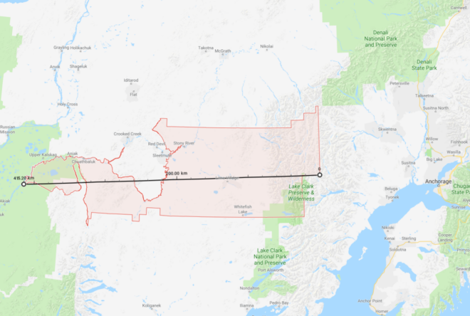
Using your phone’s GPS to identify your in-flight location, or even a standalone GPS device will usually not work once you are away from cell towers (where your GPS no longer has the assistance of A-GPS). GPS signals are very weak and your GPS receiver typically does not have an antenna strong enough to pick up the signals in an aluminum or even newer carbon fiber composite airplane like the Airbus A350 and Boeing 787. To receive a signal, an external GPS receiver is usually required and assuming that you can get a signal (it helps if the external receiver is placed by a window), we can proceed. Note that while you would expect that the CFRP body of a Boeing 787 would allow for a much stronger signal than aluminum airliners, the graphite (and probably other materials) in the 787 and A350, CFRP in conjunction with the electrochromic windows on the 787, completely block GPS signals. In addition, to protect from lightning strikes, the A350 has a metal mesh embedded in the CFRP that further reduces the signal penetrating into the aircraft body. It is this shielding as opposed to GPS jamming that blocks signals on El-Al (and other airlines) 787s and A350s. In my testing with an external GPS device designed for aviation such as the Dual XGPS 160, the composite A350 and 787 both do not allow enough GPS signal through for a GPS receiver to provide a location fix. It may be surprising that it is easier to receive the weak GPS signal in an aluminum fuselage than a composite one, but keep in mind that carbon fiber is an excellent electrical conductor. Carbon fiber was used as the filament in Thomas Edison’s early light bulbs and does not let RF signals through and effectively acts as a Faraday cage. If you are able to receive a GPS signal, you can accurately calculate zmanim for your current location using tools such as the KosherJava zmanim map. Just change the latitude and longitude to what you see in your GPS in the URL https://kosherjava.com/maps/zmanim3.html?lat=75.74&lng=-63.22&zoom=3. While not an ideal solution, it does work. The same works for the rare airlines whose maps do show accurate GPS coordinates. Please note that Wi-Fi based geolocation will not work on your flight (in my testing it gave the location of the service provider headquarters).

Precalculated Flight Paths

Another way to figure out where you are located when in the air is via a precalculated flight path. This allows programs such as the Chai Tables Chai Air Times program for Windows and Android to work. However, they just calculate a great circle route between the origination and destination locations, something that is not very accurate. Currently MyZmanim’s Inflight charts are the most practical. These charts calculate the average path of the 5 previous flights in an attempt to better estimate your flight path and provide precalculated charts based on the time you take off. Since it is just an estimate, the charts provide a relatively large window of time where zmanim may happen. This is painful and causes a lot of confusion and uncertainty, but is probably unavoidable. While this solution is currently the best that I am aware of, there are a number of issues with it. For one, much of the flight path over the oceans and Arctic that are provided by services such as FlightAware and others (that are used by MyZmanim) are just educated guesses for cross oceanic or Polar flights, since there are no ADS-B receivers in much of this area. As a matter of fact, this terrestrial ADS-B receiver-free area comprises 75% of the globe. Even if the previous flight paths were accurate, your current flight may be very different. Flights such as the Cathay Pacific flights from the NY area to Hong Kong fly either east or west depending on wind conditions. MyZmanim deals with this scenario by providing both east and west maps (based on the in-flight map you would use one or the other) and indicating the portion of a flight-path that is unknown, but this is a warning that does nothing to help you accurately calculate zmanim.

ADS-B Receivers

Every airliner broadcasts its position, heading, altitude and speed using ADS-B. A technical user can bring an ADS-B-receiver with him on the flight and use it to retrieve the current information on his flight. This would work even when there are no ground based ADS-B receivers. This is something costly and beyond the technical ability of the vast majority of flyers.

The future

Due to issues in tracking flights that came to light with the disappearance of Malaysia Airlines Flight 370, satellite based ADS-B tracking is rolling out and will be mandated. This will make it much easier for services such as MyZmanim to provide more accurate pre-flight estimates, since services such as Flight-Aware will be able to provide more exact historical flight paths. For users who do have in-flight Wi-Fi, services such as FlightAware will be able to provide almost real time location (note that many services have a 5 minute delay and are not really real-time), allowing future Wi-Fi connected zmanim apps to tap into this and provide accurate zmanim.

ZIP Codes and Zmanim – Use With Care

99557 ZIP code area (the largest in the USA)
There are many zmanim services and apps that use ZIP codes as a location finder for calculating zmanim. While very convenient, there is a potential pitfall in using ZIP codes for geolocation. In general, ZIP code geolocation services will provide the center of the ZIP code and zmanim apps calculate zmanim for that location. The issue arises with large ZIP code areas mostly found in rural areas. Take the following two extreme cases that have very large ZIP code areas. ZIP code 89049 for rural Tonopah, NV, is 195 km (121 mi) from east to west. The eastern boundary of this non-contiguous ZIP code has a longitude of -115.417°, while the western boundary is -117.625°. This means that there are 2.2° of longitude between the eastern and western borders of this ZIP code. The earth rotates 1 degree every 4 minutes, so zmanim at the eastern and western edges of this ZIP code are approximately 8.8 minutes apart. Using the typical center of the ZIP based calculations would mean that zmanim would be about 4.4 minutes different at the edges compared to the center. Moving to something a bit more extreme, is the case of ZIP code 99557 of Aniak, Alaska and its surrounding area. This ZIP code is 415 km (258 mi) from east to west. The longitude of the eastern edge of the ZIP code is -153.032°, and the western edge is -160.783°. Being farther north and therefore having shorter distances between degrees of longitude, this ZIP code stretches across 7.7° of longitude. The zmanim difference from the center to the edges of this ZIP code is 15 and a half minutes (31 minutes across the ZIP). While it is indeed rare to have such large distances, there are 193 US ZIP codes that are over 1° of longitude wide, meaning that the zmanim difference for these ZIP codes are at a minimum 4 minutes apart, or 2 minutes off from the center. There are 1,463 or 4.4% of all ZIP codes with 0.5° or greater distance between east and west (a minimum of a 2 minute zmanim difference between the east and west zide of the ZIP code). zmanim software developers should be aware of this, and take care to alert users of possible inaccuracies when using large ZIP code areas, or require addresses or more specific location information for large zip codes.
Let’s contrast the above with Lakewood, NJ. With 0.107° of longitude from east to west, zmanim are 24 seconds later on the west side (the intersection of New Central Ave & N Hope Chapel Rd) than the east side (Shinn Cranes, 1600 Ocean Ave). New York City is larger, and from the western edge of Staten Island to the edge of Glen Oaks, the eastern edge of Queens there is a 2 minute and 11 second difference in zmanim.
See the Calculation of Zmanim VS Other Sites post for additional related material.
I thank Avraham David Gelbfish for generating the ZIP code longitude range for all 33,093 ZIP codes from the US Census Bureau ZIP code shape files.

The Novaya Zemlya Effect’s Impact on Zmanim

Novaya Zemlya Effect Distorted Sun
A Distorted Sun Caused by the Novaya Zemlya Effect (Credit: Brocken Inaglory)
You may have seen disclaimers on zmanim calendars warning of up to a 2 minute inaccuracy due to weather and atmospheric conditions. Atmospheric refraction from the earth’s atmosphere, causes the sun to be visible on average about 3 minutes earlier at sunrise, and about 3 minutes later at sunset (compared to a vacuum) due to the atmosphere bending the sunlight upwards towards the viewer. The 3 minutes is only an average, and it can swing widely due to weather and atmospheric conditions. The typical variance caused by “non-average” atmospheric conditions would usually be within 2 minutes, resulting in the 2 minutes mentioned in the disclaimers. This 2 minute variance is during usual conditions, though there are conditions that would greatly increase this time.

Refraction Explained

Refraction at Sunset
When the sun’s rays traveling through the vacuum of space hit the earth atmosphere, they slow down and bend upwards towards the observer resulting in the sun being visible earlier (than in a vacuum) in the morning, and later at sunset.
Straw appearing to be bent due to refraction
Refraction of the sun’s rays is not a one stage refraction, but as the sun passes through increasingly dense layers of atmosphere, the amount of refraction increases with each thicker layer. This can be seen in the diagram of refraction at sunset above. The apparent position of the sun near sunset in the image (exaggerated in the image) is height of the sun as it appears to the user, though in reality the sun is below the horizon. Refraction can easily be observed by looking at a straw in a partially filled glass. The straw appears to bend (or be broken) at the point it enters the water. This is due to increased refraction in water versus air.

Complexity in Calculating Refraction

Since the amount of refraction depends on the pressure (the denser the atmosphere is, the greater the refraction), temperature (hot air is less dense and refracts less) and to a lesser degree humidity (water vapor in the air impacts the refraction) in each layer of the atmosphere, calculating refraction is complex and requires very detailed meteorological information on the current conditions in each layer of the atmosphere in the area being computed. This can’t be done accurately in advance, and even calculations for the current day require readings from weather balloons at multiple elevations for accurate measurement, something not very practical (though the BMG Lakewood vasikin minyan and likely other minyanim as well) manually adjust the hanetz hachama time each morning based on the weather). For this reason, zmanim (as well as civil sunrise and sunset) calculations usually use a global average refraction of 34′ of a degree, or 0.5666°. The global average atmospheric refraction accounts for sunrise being between 3:01 minutes earlier (during the solstice), and 2:29 minutes earlier (during the equinox) in Yerushalayim, as opposed to the value in a vacuum (the difference depends on where in the world you are, in Lakewood, NJ the range is 3:29 – 2:57). This average atmospheric refraction is not very accurate but is commonly used since it is complex to calculate local averages. More accurate refraction figures can be calculated for local and seasonal atmospheric models, and these have been shown to be accurate to within 15 seconds 90% of the time in the case of summer and winter subtropical models used in a study in Israel. See Using a Digital Terrain Model to Calculate Visual Sunrise and Sunset Times by Rabbi Chaim Keller and Dr. John K. Hall for additional details.

Inversion and the Novaya Zemlya Effect

Under usual conditions, the atmosphere gets colder at elevation, with the warmest air being closest to earth. An inversion condition is where there is a layer of cold air under a layer of warmer air. When there is an inversion over a large area (greater than 400 km), the solar rays get ducted in the lower colder air layer (see image below) and produce an extreme refraction. This is known as the Novaya Zemlya effect and produces a solar mirage resulting in the somewhat visually distorted sun being visible much earlier than expected (see top image).

Novaya Zemlya Effect Refraction Diagram
While typically a phenomena in the polar regions, a study by the University of Calgary showed that refraction can have a significant affect on zmanim even in non-polar areas. In the 2003 study (Variability in the Astronomical Refraction of the Rising and Setting Sun), they observed that the sunrise on January 10, 1991 appeared almost 12 minutes earlier than expected. The paper mentions:

On rare occasions, the Sun appeared to rise much earlier or set much later than predicted by such publications as the Tables of Sunrise, Sunset, and Twilight (USNO 1962). In our study, the sunrise of 1991 January 10 was almost 12 minutes early. This phenomenon is known as the Novaya Zemlya solar mirage (Lehn 1979). It appears to be caused by a geographically extensive temperature inversion within the boundary layer of the atmosphere. The resulting vertical density profile causes the sunlight to be ducted around the curvature of the Earth. For the purpose of this study, we defined anomalously large astronomical refraction to be an event with refraction greater than 1°. A total of 12 anomalous events were recorded (2.9%).

While these typically occur in cold areas, they can happen in other areas as well. The study authors mention that

The majority of the anomalous events took place in the cold months. Nine of the 12 events occurred between November 1 and April 30, with January having five events. At the time of the events, the average surface temperature was -10.9°C, and all events occurred with surface-inversion conditions. Surface inversions tend to form with overnight surface radiative cooling through a dry atmosphere. Typically, they persist into the early morning, even after sunrise. Even though most of the events took place in the cold parts of the year, the data suggest that the Novaya Zemlya solar mirage may not be an exclusively cold-weather or polar phenomenon. Four of the events occurred with a surface temperature greater than 0°C. One event took place 2 days after the summer solstice.

Refraction at Sunrise VS Sunset

The University of Calgary study found that extreme refraction is an order of magnitude more common at sunrise than sunset. The reason for the difference between sunrise and sunset is that

This may be because the lower atmosphere is better mixed during the day as a result of solar heating leading to a dry adiabatic lapse rate in the boundary layer. Anomalously large astronomical refraction events the “Novaya Zemlya solar mirage” occurred about 3% of the time and were an order of magnitude more common at sunrise than sunset.

That said, The Novaya Zemlya effect does occur at sunset and in warm climates as seen in this video of sunset in San Francisco. Sadly, the video does not include information on how long it delayed sunset.

Halacha

Halachically sunrise and sunset times depend on when we can see the sun, and not when it is at the horizon. As mentioned above, the average global refraction of 34′ results in sunrise appearing about 3 minutes earlier and sunset 3 minutes later than in a vacuum, and this refraction (or other similar refraction values) is what is used in all calendars (both halachic and civil). The fact that there is such potential for variation in weather conditions, and that the global average is likely not what is present where the zmanim are being calculated, is the reason that many luchos (zmanim calendars) have disclaimers about accuracy. Many calendars round off their zmanim without showing seconds due to the inability to accurately calculate zmanim because of refraction variations. Lahalacha the impact of earlier or later sunrise is limited to vasikin minyanim. A separate article may be needed to actually discuss sof zman krias shema and other zmanim‘s relation to sunrise and sunset VS the actual position of the sun in the sky (1/4 of the way across its path for sof zman krias shema). The halachic impact of refraction at sunset is much greater since it impacts the day/night boundary, but those are much rarer.
Now to the big question, does extreme refraction such as the Novaya Zemlya effect impact zmanim? The fact that it rarely impacts sunset, means that it almost academic since predicting the inversion before a vasikin minyan starts is impractical. In a conversation with one posek a number of years ago, he felt that the Novaya Zemlya Effect should not impact zmanim lahalacha due to the fact that unusual occurrences should not be factored in, and because the distorted sun is not considered the sun as far as zmanim. I would appreciate being notified if anyone receives a psak halacha on this question.

Zmanim Map 3.5 adds Date and Algorithm Selection

Vintage Map with CompassThe Zmanim Map was recently updated to version 3.5. This new release adds a number of new features (listed below), and some technical changes over the previous Zmanim Map 3.0 release. With this release, the main focus of the map has shifted to the zmanim tabs. The direction to Yerushalayim tab with davening directions using both the rhumb line and great circle route to Yerushalayim is still present, but is no longer the default tab.
Zmanim Map v3.5

  • The date can now be selected by the user. In previous versions the date was always the current date on the user’s computer (though the map always supported passing the date on the URL using the undocumented date=1969-02-08 parameter). The current date is still the default, but the user can now change the date.
  • The calculation algorithm is now selectable. The Zmanim API supports both the USNO and NOAA algorithms. The map has always used the USNO algorithm, and this remains the default, but users can now use the NOAA algorithm.
  • The Zmanim tab is now the default tab. This reflects user feedback indicating that most people use the map for zmanim.
  • An About tab now provides a mini user guide and general information about the map.
  • The timezone look-up now uses the Google Time Zone API. Previously the map had been using the Geo Names web service. Since the elevation service also uses Google, the change to a single stable source will hopefully result in fewer outages.
  • The currently selected tab persists across location changes, so if you were viewing zmanim for a location, and changed the location to see how the zmanim were affected, you will no longer have to change tabs after each move.
  • Candle Lighting was added for Fridays. Erev Yom Tov will not show candle lighting at this point.
  • Performance improvements, minor enhancements, bug fixes and refactoring